

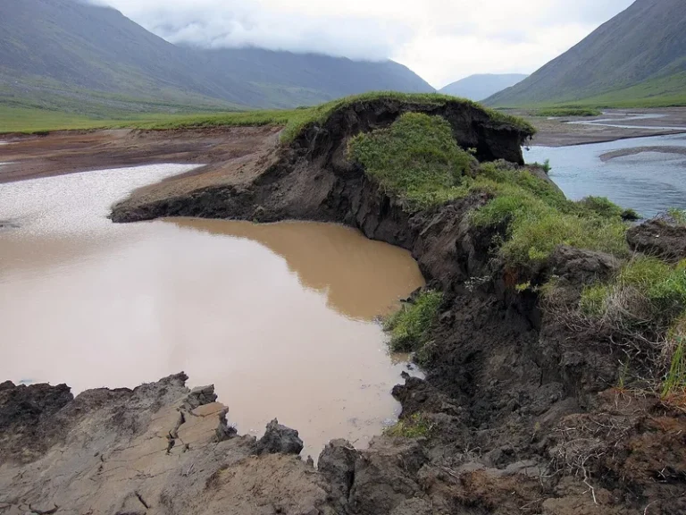

Arctic permafrost thaw has long been characterized as a gradual, top-down degradation marked by ground subsidence and slow-moving mud slurries. However, a landmark investigation published in Geophysical Research Letters documents an alarming and violent shift: permafrost landslides Canada is experiencing represent a newly recognized class of catastrophic geological failure, where entire frozen terrain slabs carrying house-sized monoliths of pure ground ice violently collapse. A research team led by Joseph Young at the University of Alberta proved that the catalyst stems from historical wildfires whose subterranean thermal waves took two decades to reach and destabilize the base of the permafrost layer.
A Sudden Geological Shift in the Arctic: Monolithic Ice Failures
Permafrost underpins nearly a quarter of the Northern Hemisphere’s landmass, encompassing vast tracts of northern Canada, Alaska, and Eurasia. Traditionally, scientists modeled permafrost thaw as a slow, gradual top-down progression: rising summer air temperatures deepen the active layer, creating shallow thaw slumps and thermokarst lakes.
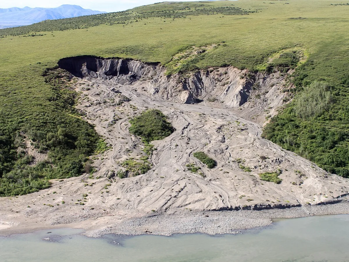
However, field surveys conducted by geoscientists from the University of Alberta and the Northwest Territories Geological Survey encountered terrain collapse of an entirely different magnitude. In northern river basins, researchers mapped gargantuan landslide scars stretching hundreds of meters across. Instead of melting into mud, immense intact slabs of frozen permafrost had sheared away and slid wholesale down gentle tundra gradients.
Within the debris deposits, researchers documented towers of pure, pristine ground ice standing up to 33 feet (10 meters) tall—equivalent to the height of a two-story home. The preservation of these sharp, monolithic ice blocks proved that failure occurred instantaneously along a deep, water-lubricated shear zone tens of meters underground.
The Wildfire Connection: A 20-Year Subterranean Time Bomb
The central enigma confronting geologists was the physical mechanism behind such deep failure. Across the study region along the Johnson and Redstone rivers, permafrost is relatively thin—ranging between 15 and 30 meters. Contemporary atmospheric summer heatwaves could not physically penetrate 20 meters into the subsoil in just a few seasons.
The missing piece was identified by co-author Steve Kokelj of the Northwest Territories Geological Survey. Cross-referencing high-resolution satellite imagery with historical wildfire registries revealed an absolute geographic correlation: every catastrophic slide originated squarely within burn scars left by severe wildfires from the late 1990s and early 2000s.
In undisturbed tundra, a thick organic insulating blanket of moss, peat, and lichen shields the underlying permafrost from summer solar radiation. When severe fires consume this protective layer, the exposed, blackened soil absorbs vast amounts of heat. Quantitative geothermal modeling revealed that it takes between 15 and 20 years for that thermal wave to propagate downward through 20 meters of permafrost.
In recent years, that thermal pulse finally struck the base of the frozen layer, initiating ‘bottom-up thawing’. Pressurized meltwater pooled along the basal contact with impermeable bedrock, destroying shear strength and causing the entire frozen massif to slide cataclysmically downslope.
Debris fans revealed intact monolithic blocks of relic ground ice measuring up to 10 to 12 meters in height—the size of a two-story house.
Combustion of insulating moss carpets triggers a slow-moving thermal disturbance that requires 15 to 20 years to penetrate 20 meters deep.
Individual slide events violently displace millions of cubic meters of frozen overburden directly into the Johnson and Redstone river basins.
Geomorphological mapping indicates that deep detachment landslides of this magnitude are unprecedented in the region over the entire Holocene epoch.
Severe Ecological Consequences and Carbon Feedback Loops
The environmental ramifications of these detachment slides ripple far beyond localized geomorphology. Catastrophic slides obliterate subarctic forests and dump millions of cubic meters of fine sediment into pristine river systems, severely muddying waterways for decades.
This massive sedimentation degrades spawning beds for indigenous fish populations and disrupts drinking water for northern Indigenous communities. Furthermore, by shearing open previously sealed Pleistocene permafrost, the slides expose thousands of years of ancient organic matter to microbial decomposition. As microbes consume this thawed organic banquet, they unleash massive volumes of carbon dioxide and methane into the atmosphere.
This triggers a dangerous positive feedback loop: global warming intensifies Arctic wildfires, wildfires ignite bottom-up permafrost thaw, landslides liberate sequestered greenhouse gases, and those emissions further accelerate atmospheric warming.
«We have documented permafrost detachment slides of unprecedented proportions. This is not gradual surface thaw, but an abrupt failure along the deep basal boundary, where soils have been warming from the bottom up for 15 to 20 years following historic burns.»
Joseph Young, Lead Author and Geoscientist at the University of Alberta
A Preview of the Arctic’s Future and Infrastructure Vulnerabilities
Scientists warn that the slides documented in Canada’s Northwest Territories provide an urgent preview of what lies ahead for warming polar environments worldwide. Climate change is driving historic wildfire records across the boreal forests of North America and Siberia.
Consequently, millions of acres of recently burned tundra are currently harboring invisible, downward-migrating thermal pulses that will reach the permafrost base in the 2030s and 2040s. This delayed destabilization poses profound risks to Arctic infrastructure, including all-weather highways, bridges, pipeline networks, and remote communities built on discontinuous permafrost.
Researchers emphasize the urgent necessity of deploying satellite radar interferometry and deep thermal borehole sensors across historic fire scars. Anticipating when and where these catastrophic detachment slides will occur is essential for mitigating disasters in our rapidly transforming cryosphere.
- Field investigations conducted across the Johnson and Redstone river valleys in Canada’s Northwest Territories.
- Identified and classified a novel geological hazard termed ‘permafrost detachment slides’.
- Discharges vast quantities of ancient, sequestered organic carbon and methane directly into the atmosphere.
- Presents immediate hazards to northern transportation corridors, pipeline networks, and pristine aquatic habitats.
Geophysical Profiling and Sub-Permafrost Pore Water Pressures
Ground-penetrating radar (GPR) and electrical resistivity tomography revealed the precise mechanics along the basal detachment plane. Pressurized sub-permafrost aquifers become trapped beneath the impermeable frozen slab, generating elevated pore water pressures.
Once hydrostatic pressure exceeds the basal frictional resistance of the underlying fine-grained bedrock contact, catastrophic shear failure occurs. The frozen slab effectively floats across a liquefied sliding surface, moving rapidly down slopes inclined by as little as three degrees.
Predictive Thermal Modeling: A Tipping Point for Boreal Permafrost
Transient thermal finite-element modeling reveals that standard IPCC cryospheric assessments have systematically underestimated permafrost degradation by focusing solely on atmospheric warming trends while ignoring post-fire radiative perturbations.
Integrating subterranean fire scar propagation demonstrates that extensive areas of boreal discontinuous permafrost across North America and Siberia will surpass basal thaw thresholds by the mid-21st century, establishing deep detachment sliding as a primary agent of Arctic terrain remodeling.