


There are only around twenty ancient lakes scattered across our planet that have held continuous water for more than a million years. As recently as the mid-twentieth century, the Aral Sea ranked as the fourth-largest inland lake in the world, acting as a vibrant hydrological oasis amidst the arid steppes and plains of Central Asia. Yet, in just a matter of decades, aggressive Soviet irrigation projects diverting its feeder rivers to water cotton monocultures led to the catastrophic evaporation of this ancient water body. Across the exposed, hypersaline lakebed emerged the aralkum desert — the planet’s youngest and fastest-growing man-made desert, entirely altering regional climate and atmospheric dynamics.
Ancient Lakes of the World: Why the Collapse of the Aral Sea Is Geologically Unique
Most modern lakes on Earth are relatively youthful geological phenomena. The vast glacial lakes found throughout Canada, Scandinavia, and Northern Eurasia formed barely 10,000 to 15,000 years ago, carved out by retreating ice sheets during the terminus of the Last Glacial Maximum. In sharp contrast, “ancient lakes” represent an exceptionally rare category of freshwater and saline water bodies that have continuously held water for over one million years. Globally, fewer than twenty such ancient basins exist, including Lake Baikal, Lake Tanganyika, Lake Ohrid, Lake Malawi, and until recently, the Aral Sea. Having persisted over vast epochs, ancient lakes serve as isolated biological islands, fostering extraordinary levels of species endemism and acting as irreplaceable repositories of paleoclimatic history.
Paleogeographical studies reveal that the Aral depression took shape through tectonic subsidence during the Late Pliocene, approximately 5.5 million years ago. For millions of years, the lake was integrated into the prehistoric Paratethys, Sarmatian, and Akchagylian inland seas that once extended from Central Europe across the Turan Lowland. Throughout the Pleistocene and Holocene epochs, the lake expanded and contracted naturally in response to glacial melt from the Pamir and Tian Shan mountain ranges, while the Amu Darya and Syr Darya rivers periodically altered their courses toward the Caspian Sea via the Uzboy channel. Yet through millennia of natural climatic upheaval, the Aral basin never fully dried out, safeguarding ancient lineages of brackish mollusks, acipenserid sturgeons, and endemic crustaceans.
The environmental tragedy that unfolded during the late twentieth century was completely unprecedented in the lake’s multi-million-year lifespan. Previous regressions occurred over centuries, allowing biological communities adequate time to adapt or retreat into river deltas. By contrast, the modern desiccation that began in the 1960s was an instantaneous anthropogenic shock. In fewer than fifty years, an immense, self-sustaining aquatic biome was systematically drained and transformed into dry earth. The lake did not succumb to a natural megadrought, but to a rigid bureaucratic initiative that viewed the natural flow of mighty continental rivers as an unacceptable waste of agricultural resources.
Birth of the Aralkum: How Desert Cotton Irrigation Drained a Giant Inland Sea
In the early 1960s, central planners in Moscow formulated an aggressive plan to achieve total national self-sufficiency in cotton production. The arid basins of the Uzbek, Turkmen, and Kazakh Soviet republics were earmarked as the agricultural hub for this thirsty monoculture, often referred to as “white gold.” Because Central Asia’s arid continental climate receives meager rainfall, Soviet planners enacted a colossal engineering mandate: divert the bulk of the runoff from the region’s two life-giving rivers, the Amu Darya and the Syr Darya. Engineers constructed thousands of kilometers of unlined irrigation trenches, headlined by the 1,300-kilometer Karakum Canal, which siphoned water away from the Amu Darya across the burning sands of Turkmenistan.
Crucially, the immense majority of these canals were gouged directly through loose sand without concrete linings or protective membranes. As a consequence, between 40% and 50% of all diverted water evaporated or seeped uselessly into the subsoil, creating stagnant marshes in the middle of the desert while starving the Aral Sea downstream. By 1980, the historical 60 cubic kilometers of annual river inflow had plummeted virtually to zero. Deprived of replenishment, the terminal lake began evaporating under the relentless Central Asian sun, its water levels falling at an alarming rate of up to one meter each year while shorelines receded by kilometers annually.
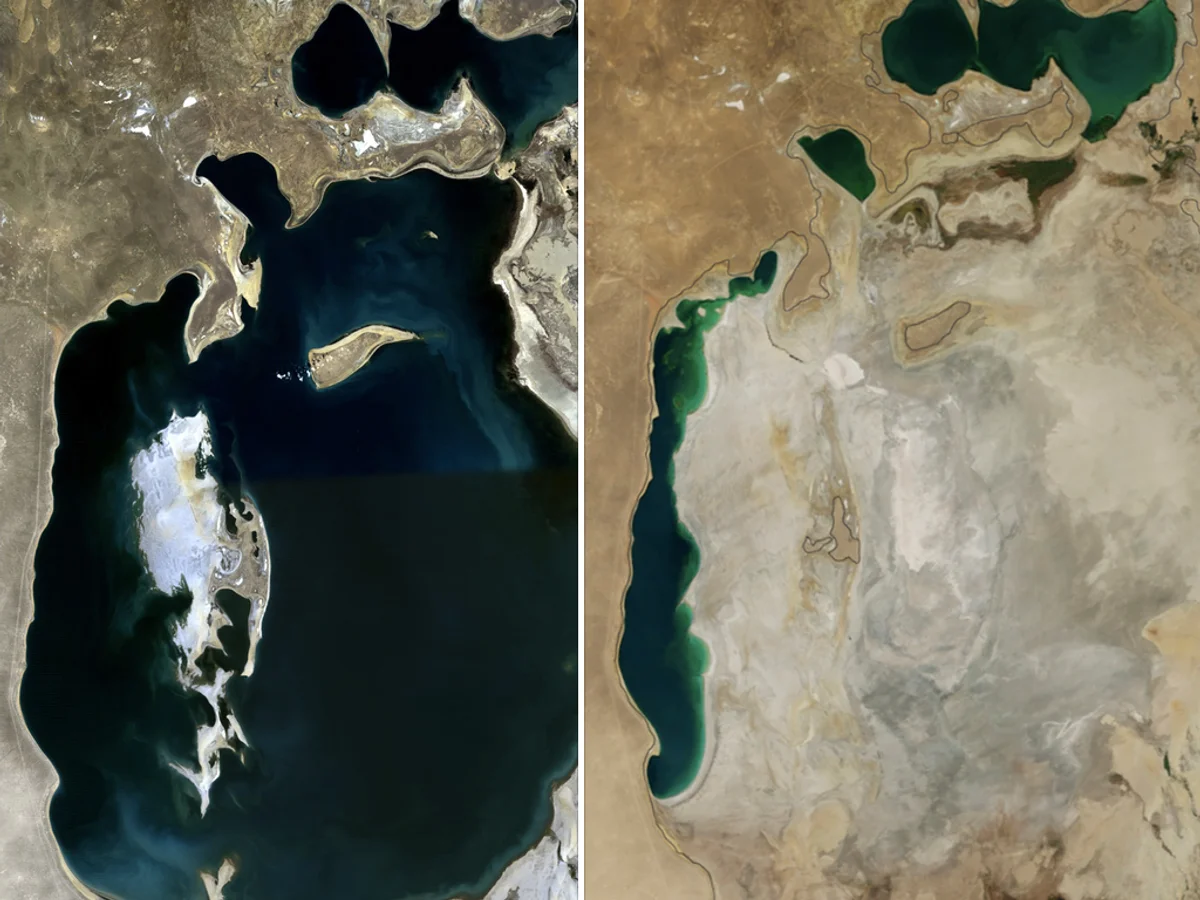
By 1989, the retreating waters severed the Aral Sea into two distinct bodies: the Small Aral Sea in Kazakhstan and the Large Aral Sea spanning the Uzbek border. In the early 2000s, the Large Aral fragmented further into deep western and shallow eastern basins. In August 2014, NASA satellite sensors recorded a historic milestone of environmental collapse: the massive eastern lobe had vanished entirely, leaving behind a contiguous expanse of bone-dry seabed. This barren salt flat came to be officially designated by geographers as the aralkum desert, encompassing more than 60,000 square kilometers of newly exposed territory.
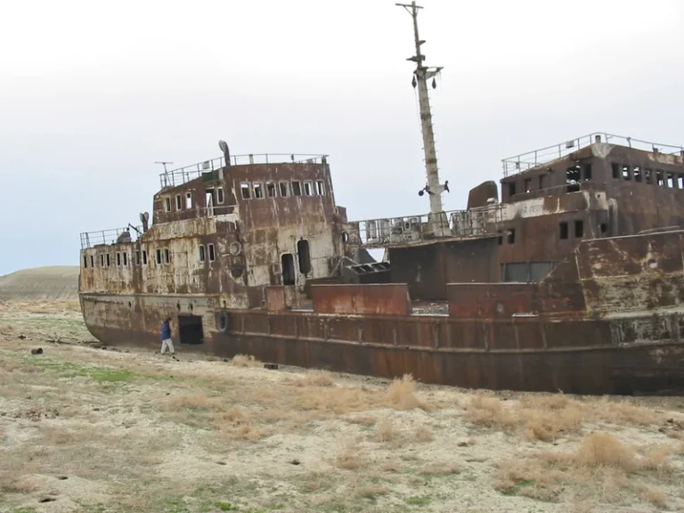
Today, the Aralkum Desert dominates vast sectors of Karakalpakstan in Uzbekistan and the Kyzylorda Region of Kazakhstan. Its landscape is an apocalyptic expanse of blinding white salt pans, mobile sand dunes, and the rusting hulks of fishing trawlers and barges abandoned at the famous “ship graveyard” near the former harbor of Moynaq. This surreal maritime graveyard stands as an enduring monument to how swiftly human engineering can dismantle one of the greatest water bodies on Earth.
The Aral basin emerged over 5.5 million years ago as a relic tectonic lake, surviving glacial cycles and long-term continental climate swings.
The 1,300-km Karakum Canal and unlined irrigation networks diverted up to 90% of the Amu Darya and Syr Darya to sustain desert cotton fields.
Gale-force winds lift up to 150 million tons of toxic salt, pesticide residue, and defoliants from the dry lakebed, dispersing them thousands of miles away.
Completed in 2005, the 13-km Kok-Aral Dam in Kazakhstan stabilized the North Aral Sea, lowering salinity and reviving local commercial fisheries.
Toxic Dust Storms and the Breakdown of Regional Climate Regulation
The rise of the Aralkum triggered catastrophic microclimatic feedback loops that reverberated across the Eurasian continent. Historically, the colossal thermal inertia of the Aral Sea acted as a regional atmospheric buffer. It softened the harsh Siberian winds of winter and tempered the blistering desert heat of summer. With the water body almost entirely gone, this moderating buffer vanished. The climate of the Aral basin transitioned into extreme continentality: winter temperatures plunged significantly, while summers grew harsher and drier, shrinking the local agricultural growing season by up to two weeks and reducing ambient humidity.
Far more menacing, however, is the deadly chemical composition of the new desert. The surface of the aralkum desert does not consist of benign quartz sand. Over four decades of intensive cotton farming, agricultural runoff laden with fertilizers and pesticides was channeled into the terminal basin. As a result, the lake sediments absorbed millions of tons of organochlorine insecticides, toxic defoliants like DDT, heavy metals, and sodium-magnesium salts. Once the lake dried, these sediments crystallized into an ultra-fine, toxic chemical dust that coats tens of thousands of square kilometers.
Fierce atmospheric depressions regularly whip up enormous salt dust storms, known locally as “white storms” or “white blizzards.” Annually, powerful gale winds loft between 75 and 150 million tons of toxic salt and pesticide dust high into the troposphere. Satellite radiometers track dust plumes stretching up to 1,000 kilometers across Uzbekistan, Kazakhstan, Turkmenistan, Iran, and Russia. Scientific field expeditions have identified trace signatures of Aral salts embedded within the glaciers of the Pamir and Tian Shan mountains, and even within polar ice cores in Greenland. By darkening the surface of Central Asian glaciers, this corrosive deposition lowers their albedo, vastly accelerating glacial melting and threatening the long-term freshwater security of the entire region.
«The desiccation of the Aral Sea and the rapid emergence of the Aralkum Desert represent one of the most devastating man-made environmental disasters in human history. We destroyed a unique limnological system that endured for millions of years in the span of a single generation.»
Dr. Philip Micklin (Philip Micklin), Professor Emeritus of Geography at Western Michigan University
Humanitarian Fallout: Disease, Deprivation, and the Loss of Maritime Culture
For the indigenous populations of the Aral basin — Karakalpaks, Kazakhs, and Uzbeks — the demise of the sea brought an economic collapse accompanied by a severe public health crisis. Prior to 1960, the Aral Sea supported a thriving commercial fishing industry. Fleets caught upwards of 40,000 metric tons of commercial fish annually, including carp, bream, pike-perch, and the ancient ship sturgeon. State-of-the-art canning factories in Moynaq and Aralsk employed tens of thousands of workers, anchoring a vibrant maritime culture and supporting generations of fishing families.
As the sea evaporated, the salinity of the residual Large Aral soared from an original 10 grams per liter to over 100–150 g/L, far exceeding the salinity of the open ocean. Virtually all freshwater fish species perished, shipping lanes ground to a halt, and former harbor towns were left stranded tens of kilometers inland. In an instant, the local economy unraveled. Unprecedented unemployment, deep poverty, and forced migration hollowed out communities that had thrived on the lake’s shores for centuries.
This economic devastation was compounded by a catastrophic health emergency caused by contaminated groundwater and the chronic inhalation of toxic airborne dust. The Aral region exhibits some of the highest maternal and infant mortality rates in the former Soviet Union. Epidemics of chronic bronchitis, asthma, multidrug-resistant tuberculosis, esophageal cancer, and kidney failure have become tragic everyday realities. Bioanalytical testing revealed alarming concentrations of dioxins and toxic agrochemicals in the breast milk of nursing mothers, drastically exceeding World Health Organization safety standards. Just as disrupting subterranean ecological linkages compromises underground mycelium networks and forest nutrient distribution, severing the natural hydrology of the Aral basin broke the vital lifelines sustaining human communities.
- The Aral Sea was the fourth-largest inland water body on Earth, spanning 68,000 square kilometers prior to massive irrigation diversion in 1960.
- Diversion of the Amu Darya and Syr Darya rivers slashed annual freshwater inflow by more than 90%, causing water levels to drop over 20 meters.
- The completely desiccated eastern seabed has given rise to the Aralkum Desert, covering over 60,000 square kilometers of hyper-saline ground.
- Aerosolized Aral dust and agricultural agrochemicals have been detected in glaciers across the Pamirs, the Tian Shan, and even Greenland ice cores.
- The construction of the Kok-Aral Dam successfully revived the North Aral Sea to 42 meters elevation, showing the potential for localized ecological repair.
Reviving the North Aral and Sand Stabilization: The Frontiers of Restoration
Following the dissolution of the Soviet Union, regional experts realized that completely restoring the Aral Sea to its historical borders was practically impossible; doing so would necessitate shutting down agricultural economies across five sovereign Central Asian nations. However, Kazakhstan, in partnership with the World Bank, resolved to save the northern remnant. In 2005, engineers completed the monumental Kok-Aral Dam — a 13-kilometer concrete and earthen dike across the Berg Strait that physically separated the Small Aral Sea from the desiccated southern basin.
The environmental payoff exceeded every projection. By impounding the inflow of the Syr Darya river, the North Aral Sea filled far faster than computer models had anticipated: water levels rose from 38 meters to 42 meters in only eight months. The water body’s surface area expanded by 20%, while salinity fell from 30 g/L down to a healthy 8–10 g/L. Commercial freshwater fish such as pike-perch, carp, and bream rebounded dramatically. Today, the fish processing plant in Aralsk is operational again, annual fish harvests exceed 8,000 tons, and the coastline has advanced to within 15 kilometers of the town.
Conversely, the southern basin in Uzbekistan cannot be recovered through river flows alone, as the Amu Darya remains heavily exploited for agriculture. Consequently, Uzbek scientists and international forestry agencies have turned to phytomelioration to stabilize the Aralkum Desert. Workers are planting hundreds of thousands of hectares of black saxaul (Haloxylon aphyllum), tamarix, and other hardy halophytes. The deep, expansive root systems of saxaul bind shifting sand dunes, dampening wind erosion and significantly curtailing the release of toxic dust into the atmosphere.
The transformation of the Aral Sea into the Aralkum Desert remains an indelible cautionary tale for modern civilization. It underscores how swiftly fragile hydrogeological systems, sculpted over millions of years, can be undone by unconstrained technocratic arrogance. While the rescue of the North Aral Sea proves that targeted ecological remediation is achievable, the sprawling salt flats of the Aralkum will endure for centuries as a stark monument to the ecological consequences of defying nature.