


For over a century and a half, European imperial historiography championed the enduring myth of the solitary white explorer—a courageous adventurer in a pith helmet who penetrated the «Dark Continent» with sextant and compass to single-handedly plot its terra incognita onto scientific maps. However, a landmark archival investigation conducted by Thomas J. Bassett, Professor Emeritus of Geography at the University of Illinois Urbana-Champaign, has definitively dismantled this Eurocentric narrative. By dissecting original field journals, route surveys, and composite government map sheets from the 19th century, Bassett demonstrated that landmark colonial maps of Africa were hybrid productions of complex intercultural encounters, where up to 65% of all recorded route networks, river systems, and settlements were directly surveyed, calculated, and drafted in the sand by indigenous African guides, interpreters, and caravan traders.
Sand Maps of the Sahara and Straw Distances: Indigenous Spatial Intelligence
Contrary to colonial assumptions that pre-literate African societies lacked sophisticated cartography, indigenous traditions of spatial representation were widespread, precise, and highly valued. Route mapping was fundamental to long-distance trade, transhumance, and imperial governance. Seasoned caravan leaders held encyclopedic mental gazetteers encompassing thousands of kilometers of arid tracks, oasis depths, seasonal mountain passes, and royal capitals.
When European military explorers inquired about unfamiliar territories, African intermediaries communicated detailed spatial schematics by drawing routes directly on the sand with walking sticks or arranging varied lengths of straw on the ground to denote proportional travel times between trading centers. French explorer Henri Duveyrier acknowledged in his 1861 study of the northern Sahara that over a third of his published map was drafted directly from sand sketches provided by his Tuareg guide, Cheikh-’Othmàn.
Similarly, in his 1892 travel memoir, French Navy Lt. Louis-Gustave Binger reproduced the layout of Niellé, a fortified city in northern contemporary Ivory Coast. When Niellé’s ruler barred Binger from entering the settlement, his African interpreter, Fofana Diawé, drew an intricate ground map of the town’s defensive ramparts and concentric streets, which Binger meticulously copied into his field diary.
The Secret of the Dashed Lines: How Marchand’s Landmark Survey Relied on Locals
The most compelling graphic testament to hybrid cartography is the landmark map of the region between the Niger River and the Gulf of Guinea drafted in the early 1890s by French Navy Lt. Jean-Baptiste Marchand. Marchand adopted a rigorous visual convention: routes he personally traversed alongside other European officers were engraved as bold solid lines, whereas geographical intelligence provided by local African informants was rendered as dashed lines.
When modern researchers tallied the aggregate linear mileage of every trail and waterway on Marchand’s map, the calculation yielded a startling revelation: locally sourced African routes accounted for an overwhelming 65% of the total recorded network. Local intermediaries provided accurate hydrographic branches of the Niger River, forest shortcuts, and secure river crossings that European boots had never touched.
This profound dependence on indigenous knowledge mirrors other historical paradigm shifts: just as modern fitness and military physical cultures evolved out of specific historical realities, European territorial mapping was fundamentally subsidized by the intellectual capital of the populations being surveyed.
«National archives in Europe contain countless maps layered with solid and dashed lines. 19th-century soldier-surveyors used dashed lines to mark locally sourced route information, presuming these tentative itineraries would eventually be supplanted by European triangulation. Yet when we calculate the total linear distances on these landmark maps, nearly two-thirds of the recorded routes stem entirely from indigenous African cartographic practices. Europeans merely claimed the authorial credit.»
Thomas J. Bassett, Professor Emeritus of Geography at the University of Illinois Urbana-Champaign
Debunking the Kong Mountains: How African Guides Vanished a Phantom Range
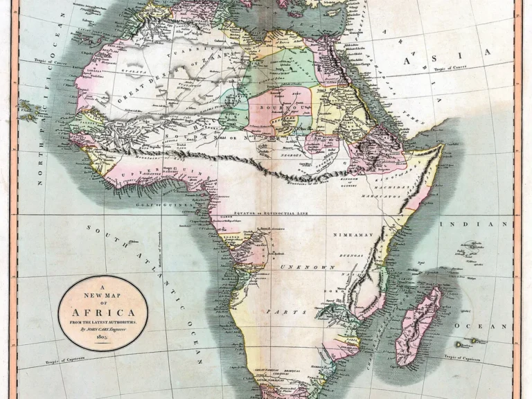
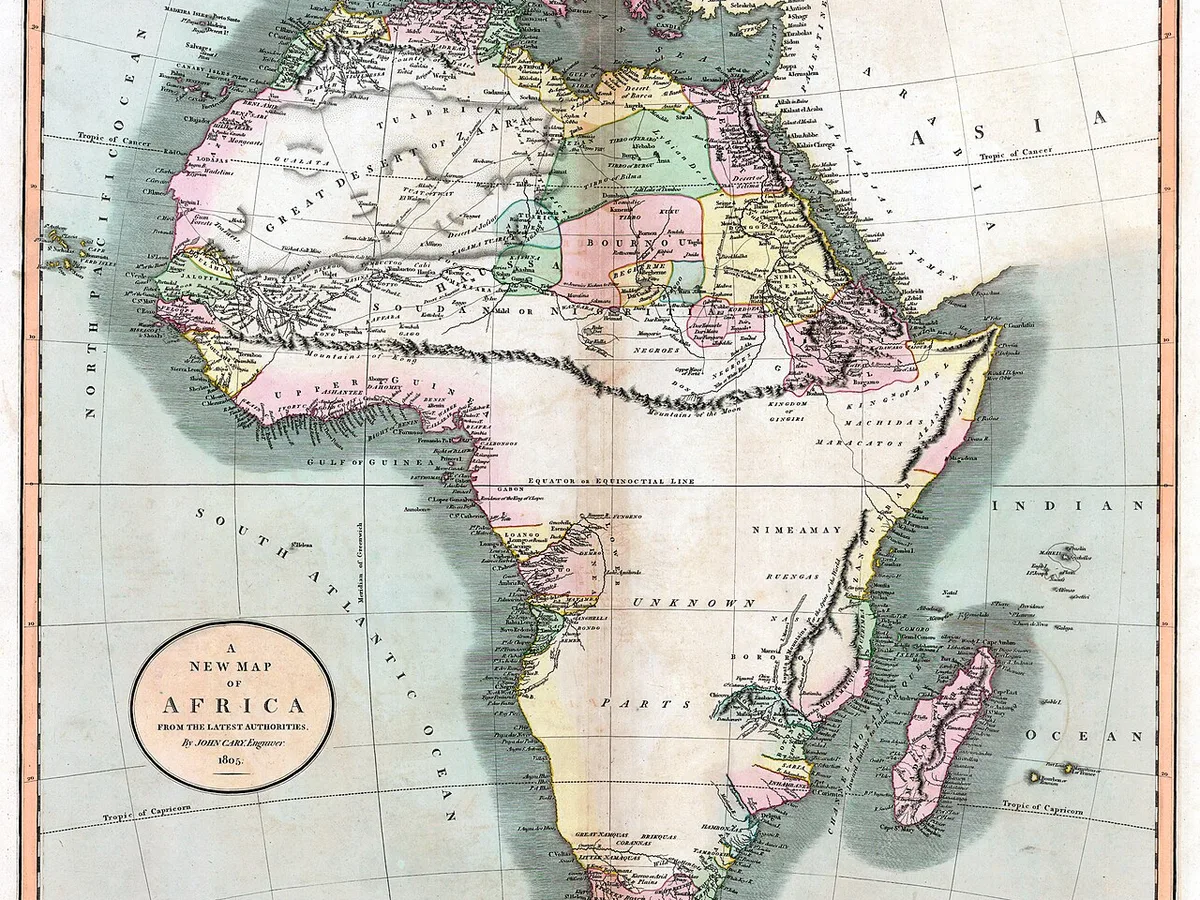
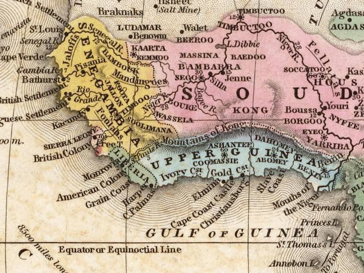
Among the most notorious errors in cartographic history was the persistent myth of the «Mountains of Kong». Beginning with British cartographer John Cary’s 1805 map of Africa and enduring across eight decades of European geography, an immense, snow-capped mountain barrier was depicted stretching uninterrupted across West Africa from east to west.
Based on speculative extrapolations from Scottish explorer Mungo Park, the fictitious mountain chain appeared in authoritative school atlases, encyclopedias, and colonial ministry planning boards until late into the Victorian era. European cartographers unthinkingly duplicated the phantom peaks from one compilation to the next, treating them as verified physical geography.
The illusion was shattered only when Louis-Gustave Binger followed the advice of Mandinka traders. Rather than confronting an impassable alpine wall, Binger was guided through a gently undulating, fertile savanna, proving the Kong Mountains did not exist. Erasing the imaginary range revealed an accessible highway through the interior, vastly accelerating French military colonization of the Upper Volta.
Dashed lines designating indigenous African route surveys accounted for nearly two-thirds of all plotted roads on the landmark map.
African guides led European surveyors through flat savanna, erasing an imaginary mountain chain that graced atlases for 80+ years.
Sophisticated indigenous spatial techniques used by Tuareg guides like Cheikh-’Othmàn to chart Saharan wells and fortified towns.
Colonial powers drew imperial borders using Habenicht and Lannoy maps heavily constructed upon indigenous African exploration data.
The Truth Behind Blank Spaces: Active Geopolitical Resistance by African Rulers
On European imperial maps, vast interior territories were frequently emblazoned with «Terra Incognita» or left entirely blank. Traditional historical commentary viewed these blank spaces as emblems of scientific modesty: cartographers depicting only what empirical European instruments had measured.
However, Bassett’s examination of military logs exposes a radically different dynamic: blank spaces frequently materialized where astute African kings, sultans, and chiefs explicitly forbade Europeans from traversing their domains. Rulers of the Bambara, Ashanti, and Sokoto Caliphate recognized that soldier-surveyors carrying theodolites were not benign scientists, but military scouts plotting roads for conquest.
In his expedition memoirs across modern-day Mali and Burkina Faso, Binger noted that the conspicuous white voids on his four-sheet map were caused directly by rulers denying him safe conduct and threatening guides with execution if they assisted. Blank spaces on maps were not reflections of African emptiness, but monuments to African geopolitical defiance.
- Colonial maps of Africa represent hybrid intercultural productions rather than unilateral European achievements.
- Indigenous guides possessed sophisticated spatial orientation traditions, translating oral maps into accurate physical charts.
- Blank spaces on 19th-century maps denoted sovereign zones of active military and diplomatic resistance to European intrusion.
- European cartographers systematically erased or subordinated indigenous intellectual authorship on published imperial maps.
The 1884 Berlin Conference: African Cartography Partitioning the Continent
The tragic irony of African cartographic agency culminated during the winter of 1884–1885 at the Berlin West Africa Conference, where Chancellor Otto von Bismarck and European diplomats partitioned the continent into colonial spheres. Dominating the conference chamber were massive wall maps compiled by Hermann Habenicht and Régnauld de Lannoy de Bissy.
Both of these influential maps relied extensively on African geographical intelligence: in Central Africa, European mapmakers incorporated route surveys drafted by African trading agents Pedro João Baptista and Amaro José, while in the Sahel, routes surveyed by Senegalese explorers Roger Panet and Bou El Mogdad Seck were featured. On Lannoy de Bissy’s 1882 Ségou-Sikoro sheet, more than two-thirds of the route data was generated by Africans.
Visual and spatial traditions hold profound historical resonance: much like how Hokusai’s Great Wave reveals its genuine mastery only within the context of the complete 46-print series, 19th-century maps of Africa yield their true historical meaning only when we acknowledge the indispensable intellectual authorship of the indigenous peoples who walked, measured, and drafted those lands.